PAST, PRESENT AND FUTURE PERSPECTIVES ON THE INTEGRATION OF AI INTO WALKABILITY ASSESSMENT TOOLS
A systematic Review
Yasin Delavar, Sarah Gamble, and Karla Saldana-Ochoa
,
ABSTRACT
This study employs a systematic literature review (PRISMA methodology) to investigate the integration of Artificial Intelligence (AI) in walkability assessments conducted between 2012 and 2022. Analyzing 34 articles exploring data types, factors, and AI tools, the review emphasizes the value of utilizing diverse datasets, particularly street view images, to train supersized AI models. This approach fosters efficient, unbiased assessments and offers deep insights into pedestrian environment interactions. Furthermore, AI tools empower walkability assessment by facilitating mapping, scoring, designing pedestrian routes, and uncovering previously unconsidered factors. The current shift from large‐scale spatial data analysis (allocentric perspective) to a ground‐level view (egocentric perspective) and physical and perceptual features of walking introduces a subjective lens into current walkability assessment tools. However, the efficacy of current methods in addressing non‐visual aspects of human perception and their applicability across diverse demographics remains debatable. Finally, the lack of integration of emerging technologies like virtual/augmented reality and digital twin leaves a significant gap in research, inviting further study to determine their efficacy in enhancing the current methods and, in general, understanding the interaction of humans and cities.
KEYWORDS: artificial intelligence; digital twin; human perception; urban built environment; walkability; walkability assessment; walkable environment
1. INTRODUCTION
Walkability is a key concept in urban design that supports pedestrian activity by ensuring comfort, safety, connectivity, and visual appeal, ultimately benefiting public health, transportation, and environmental sustainability. It results from the interaction between diverse pedestrian needs and various elements of the built environment, which can be assessed from both ground-level (egocentric) and aerial (allocentric) perspectives. Traditional, manual assessment methods are resource-intensive, but AI offers a transformative approach by automating data gathering and analysis. This integration of diverse data sources—subjective and objective, qualitative and quantitative—enables more comprehensive, efficient, and data-driven evaluations to support better urban planning decisions.
Motivated by the importance of walkability in urban environments and harnessing the potential of AI, the present study aims to provide a solid basis for advancing future walkability measurement tools. The study identifies and examines recent research in the field of walkability that incorporates AI methodologies and data analysis that could feed into this domain. Our analysis centers around three key research questions:
RQ1: How do AI models and emerging technologies enhance understanding of specific aspects of human perception related to walkability, such as safety, comfort, and aesthetics?
RQ2: How can spatial, physical, and perceived walkability features (e.g., street connectivity, barriers, and aesthetics) be effectively extracted and integrated into AI models to provide comprehensive walkability assessments?
RQ3: What specific gaps exist in current research, and what potential applications of AI and emerging technologies remain unexplored?
By systematically analyzing these research questions, this study aims to establish a robust foundation for developing and implementing future walkability assessment tools that are not only technologically advanced but also cater to the unique requirements of various populations. This, in turn, will contribute to the improvement of walkability in urban environments for all. The remainder of the article is structured as follows. Section 2 briefly reviews some of the past walkability measurement methods. Section 3 details the methodology employed for the systematic literature review following the PRISMA guidelines. Section 4 presents a comprehensive analysis and classification of the identified research findings. Finally, Section 5 discusses the future of walkability assessment and outlines promising avenues for future research in this domain.
2. BACKGROUND ON WALKABILITY ASSESSMENT
Academics and practitioners assess walkability using various methods, including index systems, subjective questionnaires, and big urban data analyses. Public tools like Walkscore and the US National Walkability Index rely on allocentric data, often overlooking on-the-ground conditions. Recent platforms and guidelines have emerged for evaluating street environments, yet they still predominantly use allocentric data, creating a gap with the subjective, localized (egocentric) experiences of pedestrians. Previous literature reviews have underscored two critical factors for effective walkability tools: the assessment scale and the hierarchical arrangement of influencing factors.
3. METHODOLOGY
The literature review targets research at the intersection of AI tools and built environment walkability assessment, categorizing studies based on AI methodologies—teaching (datasets), learning (algorithms), and inference (validation). It examines studies from 2012 to 2022 using databases such as Scopus, Web of Science, and ScienceDirect. Following PRISMA guidelines and excluding research solely on pedestrian interaction or cycling, 34 articles were selected for detailed analysis. These articles were evaluated across five dimensions: general information, objectives, methodology, findings, and limitations, with a focus on study characteristics, data types, perspectives, and the AI tools employed.
3.1. TOPIC MODELING
A topic modeling analysis investigates the lexical patterns employed in studies to ascertain trends. The technique is a valuable indicator of topics and trends representing the selected literature’s corpus by analyzing the abstract content (Ochoa, 2021).
Table 1. Search strings queries within Scopus, Web of Science, and ScienceDirect databases.
Search query strings
(“AI”) and (“walkability”)
(“AI,” “deep learning,” or “machine learning”), (“walkability” or “pedestrian environment”), and (“measurement”)
(“AI,” “deep learning,” or “machine learning”) and (“walkability” or “pedestrian environment”)
(“AI,” “deep learning,” or “machine learning”) and (“walkway,” “footpath,” “pedestrian path,” “pedestrian mobility,” or “active transportation”)
(“Automatic information extraction”) and (“walkability”)
(“Automatic information extraction”) and (“walkway,” “footpath,” “pedestrian path,” “pedestrian mobility,” or “active transportation”)
(“Image processing,” “computer vision,” “scene recognition,” or “image recognition”) and (“walkability”)
(“Image processing,” “computer vision,” “scene recognition,” or “image recognition”) and (“pedestrian” and “walking”)
(“Measure,” “measuring,” or “measurement”), (“automated,” “automation,” “automating,” or “automatic”), and (“walkability,” “walkway,” “pedestrian environment,” or “walkable”)
Note: These search string queries were conducted within the articles’ title, abstract, author keywords, and keywords plus (suggested keywords by the databases).

Figure 1. PRISMA flowchart of the systematic review process.
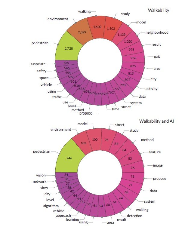
Topic modeling was used to compare two sets of studies—700 articles on “walkability and AI” and 4,967 broader “walkability” articles from 2012 to 2022. While both sets shared common terms like “pedestrian,” “environment,” and “system,” the “walkability and AI” literature featured terms such as “learning,” “street audit,” “imagery,” and “view,” emphasizing AI’s role in street-level image analysis. In contrast, the broader walkability research focused on words like “public,” “safety,” “walk,” and “design,” reflecting a traditional focus on urban planning and infrastructure.

Figure 2. A 10‐year analysis of lexical distribution in published literature on “walkability” (top) and “walkability and AI” (bottom).
“view,” reflecting the use of AI technologies to improve walkability assessment by analyzing imagery data at the street level. The search for “walkability” alone highlighted terms such as “public,” “safety,” “walk,” and “design,” which reflect the focus on urban planning and infrastructure design to improve the quality of the walkability experience.
In the broader “walkability” research articles, the most common words are “environment,” “walking,” “study,” “neighborhood,” “area,” “city,” and “activity.” These terms focus on the physical aspects of walkability, such as the built environment, urban design, and promoting walking as a physical activity. On the other hand, the literature on “walkability and AI” highlights different words, including “model,” “street,” “study,” “method,” “feature,” “image,” and “data.” These terms indicate a focus on using AI technologies to analyze and improve the subjective features of the walkability of urban environments by developing models and methods that can be applied to street‐level imagery data.

Figure 3. Lexical frequency in published literature on “walkability” (top) and “walkability and AI” (bottom), 2012–2022.
4. RESULTS
The table in the Supplementary File summarizes the results and the different attributes considered for the analysis, categorized in the following subsections.
4.1 USE AND PERSPECTIVE
The text distinguishes between two classification types in walkability assessment. Use classification addresses demographic-specific needs—such as safe routes for children, accessible pavements for the elderly, and gender-related safety concerns—while perspective classification relates to the viewpoint used: egocentric perspectives capture the subjective, ground-level pedestrian experience through street view imagery, whereas allocentric perspectives provide an objective, aerial view using GIS and aerial data. Research, predominantly from Asia, North America, and Europe, mainly favors egocentric approaches, with 17 studies using this method, six using allocentric, and eight combining both. One notable study even incorporated wearable sensor data to analyze pedestrian behaviors.
4.2 AI IN WALKABILITY ASSESSMENT
Our approach to classification is based on the three stages of AI’s methodology involving: teaching, learning, and inference (Ochoa & Comes, 2021).
4.2.1 Teaching: Data Types, Features, and Factors
In the teaching stage, models are trained using labeled data—comprising input features and corresponding outputs—to learn patterns and accurately predict new outcomes. The studies reviewed primarily use five data types: geospatial, imagery, historical, sensor, and survey data, with imagery being the most prevalent. Imagery data, including street view, aerial, and panoramic images, is labeled based on urban features like sidewalk conditions and greenery. Geospatial data offers spatial context through land-use classifications, street networks, and traffic metrics, while sensor data (from remote sensing and wearables) and historical data (pedestrian counts and accident records) provide additional insights into environmental and human factors. Researchers often combine these diverse data sources—using methods such as convolutional neural networks and decision support systems—to enhance model accuracy in assessing walkability and pedestrian accessibility.
4.2.2. Learning: AI Tools
In the learning stage, a model is trained on test data and its accuracy is evaluated before moving to inference. The choice of algorithms depends on the labeled data, with a range of approaches including machine learning, expert systems, computer vision, and robotics. Machine learning is predominant, especially supervised techniques like decision trees and convolutional neural networks (CNNs), which excel at identifying both physical and perceptual walkability features (e.g., sidewalk dimensions, greenery, and shade). Studies also use image segmentation and instance segmentation for detailed feature mapping, while robotics aids in data collection. Researchers often combine multiple methods—using expert systems for GIS data and computer vision for street-view images—to develop comprehensive walkability indices.
4.2.3. Inference: Validation and Research Findings
The text describes how, during the inference stage, a trained AI model uses learned relationships to predict outcomes on new data. It reviews various methods for evaluating walkability—from indices measuring safety, comfort, and accessibility to models that factor in additional data like walking time and biosignals. Researchers employ both traditional metrics and automated mapping techniques (e.g., detecting sidewalk features and hazards) to assess pedestrian routes. Moreover, AI is used to explore the links between walkability and factors such as mental health, elderly mobility, and urban design. This comprehensive approach aims to provide a more nuanced, scalable, and efficient understanding of walkability in the built environment.
4.3. Limitations and Existing Gaps
Current walkability assessments face significant challenges due to limitations in data, evaluation methods, and AI accuracy. Complex data sources—like street view images, GIS, and surveys—are hard to integrate, and models struggle with issues such as misaligned viewpoints, inconsistent image quality, and bias in spatial distribution. Additionally, these methods often fail to capture subjective, non-visual factors (e.g., aesthetics, soundscapes, and air quality) and do not adequately represent diverse demographic experiences. While emerging technologies like VR/AR, digital twins, and wearable sensors offer promising improvements, their potential remains largely untapped, and scaling findings from localized studies to broader areas continues to be a major hurdle.
5. DISCUSSION
Advancements in street view imagery and image processing have enabled AI—primarily neural networks—to assess walkability through feature detection, mapping, scoring, and route design, shifting the focus from objective metrics to subjective, pedestrian-level perceptions. However, challenges such as inconsistent image quality, misalignment with human viewpoints, and the inability to capture subtle experiential factors (e.g., micro-barriers and human perception) remain. These issues highlight the need to integrate manual and human data sources, and future research should leverage emerging technologies like digital twins, eye tracking, biosensors, and VR/AR to develop more comprehensive training models for walkability assessment.
6. CONCLUSION: FURTHER RESEARCH AND OUTLOOK
Digital twins and VR/AR technologies enable the creation of controlled virtual streetscapes that integrate diverse data sources such as GIS, street imagery, and real-time sensor readings. Researchers can simulate various conditions—like traffic density and green space—and use immersive techniques (including eye tracking and virtual pedestrian agents) to gather detailed feedback on safety, comfort, and walkability. Additionally, AR glasses can overlay digital information in real-world settings, while AI analyzes data from AR wearables to identify walking patterns and environmental interactions. This innovative approach shifts walkability assessments toward capturing the subjective and cognitive experiences of pedestrians, benefiting studies on specific populations, despite challenges in accessibility, inclusivity, and data privacy.
To read more about it see the below link:
https://doi.org/10.17645/up.8518
Gallery